
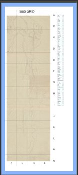
1865 Map of the Colville Valley. This is a big map to download but has key information in the index about over a hundred families living in the Colville Valley in 1865. They include native families, farming the valley, retired fur traders and their mixed blood families, retired military men and American Settlers. We intend to build stories about these people, many of whom have relatives nearby.
The name index shows where on the map to look for each name. The map was not geographically referenced so pinpointing a residence from the map is not advisable. It will however show the general location.
You can look at the list of name index directly here.

This map also shows locations of residences as well as both Hudson’s Bay Fort Colvile and Military Fort Colville around 1865. Be aware that it is rotated 90 degrees to the left so North is on the left side of the map. It was scanned by the National Archives from records used in settling HBC land claims with information submitted by Angus McDonald.